Monday, September 28, 2020

Oldest Roman body armour found in Germany


Archaeologists have discovered the oldest and most complete Roman body armour at the site of the  Battle of the Teutoburg Forest in Kalkriese, Germany. Before this find, the earliest known examples of Roman lorica segmentata — iron plate sections tied together — were found in Corbridge, UK, and date to the 2nd century. Those were fragments. The Kalkriese armor is a complete set, and includes an extremely rare iron collar used to shackle prisoners.

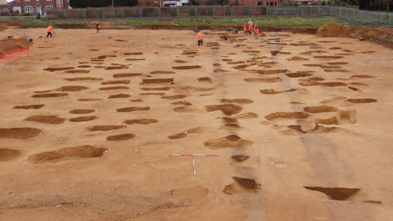
More than 7,000 objects have been found at the Kalkriese battlefield site, from weapons to coins to items of everyday use. In the summer of 2018, a metal detector scan of the side wall of an excavation trench retuned 10 strong signals, indications of a large quantity of metal inside the bank. To ensure whatever was in there wasn’t exposed to the air and rapid oxidization, archaeologists removed the entire soil block containing the mystery metallics.

The first step was to scan the block to see what was inside and map out its excavation. The block was too big for regular X-ray machines, so  they transported the crate to the Münster Osnabrück International Airport where the customs office has a freight-sized X-ray machine. All they could see was nails of the wooden crate and a large black hole in the shape of the soil block.

In 2019, it was sent to the Fraunhofer Institute in Fürth which has the world’s largest CT scanner — a circular platform more than 11 feet in diameter that rotates while the X-ray apparatus moves up and down — more than big enough for the crate to fit and powerful enough to see inside the dense soil block. The scan revealed the remains of a cuirass — the section of a lorica segmentata where the breastplate and back plate are buckled together. The plates of the armour were pushed together like an accordion by the weight of the soil pressing on down them for 2,000 years.

Here’s a nifty digital animation by the Fraunhofer Institute generated from the CT scan data that reveals the armour inside the soil block.


Armed with the detailed scans, restorers were able to begin excavation of the soil block. They found that despite Kalkriese’s highly acidic sandy soil, the armour is relatively well-preserved. There is extensive corrosion of the mental, but the set is uniquely complete with hinges, buckles, bronze bosses and even extremely rare surviving pieces of the leather ties. The plates from the shoulder and chest have been recovered and restored. The belly plates are still in the soil block. There are no arm plates in this early design.

Iron plate armour was introduced by Augustus as an improvement on chain mail. It was relatively light (around 17 pounds) and because the plates were tied together with leather cords, they were much more flexible than chain mail. so it was the latest and greatest technology in 9 A.D. when Publius Quinctilius Varus blundered into a German ambush that obliterated three full Roman legions plus their auxiliaries.

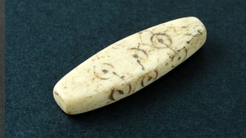
The legionary who wore this armour apparently survived the battle because around his neck/shoulder area was a shrew’s fiddle, also known as a neck violin. This was an iron collar connected to two handcuffs that locked a prisoner’s hands in front of his neck. The Romans used them to shackle prisoners destined for slavery. This time the tables were turned, and the soldier died in shackles.

The restoration is ongoing and is expected to take another two years. Once it’s complete, the armour will go on display in an exhibition at the Kalkriese Museum and Park.

Read the rest of this article...

Six African heritage sites under threat from climate change


From rock art in southern Africa to pyramids along the River Nile, humans have been leaving their mark across the continent for millennia.

But extreme weather events, the rise in sea levels and other challenges associated with the changing climate are threatening to destroy invaluable cultural landmarks, a recent study warns.

Writing in the Azania journal, researchers from the UK, Kenya and the US say that "significant intervention" is needed to save these heritage sites.

As if to underline the warning, in recent weeks archaeologists in Sudan have been trying to stop floodwater from the River Nile from reaching the UN-designated World Heritage Site at al-Bajrawiya.

Read the rest of this article...

The only Viking helmet ever found in the UK


Collections Officer Christine Hutchinson of Preston Park Museum in Stockton on Tees on a locally-found Viking helmet that is the only one of its kind in the UK
This is the only Viking helmet to be found in the UK and only the second near complete one to be found in the world, so it’s an amazing discovery.

It was however found back in the 1950s by workmen digging trenches for sewage pipes in Yarm – just down the road from us – and we know that no archaeological surveys were done at the time. So up until very recently there was always a kind of question mark over it.

Read the rest of this article...

How Neanderthals lost their Y chromosome


Neanderthals have long been seen as uber-masculine hunks, at least compared with their lightweight human cousins, with whom they competed for food, territory, and mates. But a new study finds Homo sapiens men essentially emasculated their brawny brethren when they mated with Neanderthal women more than 100,000 years ago. Those unions caused the modern Y chromosomes to sweep through future generations of Neanderthal boys, eventually replacing the Neanderthal Y.

The new finding may solve the decade-old mystery of why researchers have been unable to find a Neanderthal Y chromosome. Part of the problem was the dearth of DNA from men: Of the dozen Neanderthals whose DNA has been sequenced so far, most is from women, as the DNA in male Neanderthal fossils happened to be poorly preserved or contaminated with bacteria. “We began to wonder if there were any male Neanderthals,” jokes Janet Kelso, a computational biologist at the Max Planck Institute for Evolutionary Anthropology and senior author of the new study.

Read the rest of this article...

Tuesday, September 22, 2020

Sweeping DNA Survey Highlights Vikings’ Surprising Genetic Diversity

Vikings' maritime expeditions brought them out of Scandinavia and into Northern Europe, where they intermingled with local populations. (Pmxfuel)

The term “Viking” tends to conjure up images of fierce, blonde men who donned horned helmets and sailed the seas in longboats, earning a fearsome reputation through their violent conquests and plunder.

But a new study published in the journal Nature suggests the people known as Vikings didn’t exactly fit these modern stereotypes. Instead, a survey deemed the “world’s largest-ever DNA sequencing of Viking skeletons” reinforces what historians and archaeologists have long speculated: that Vikings’ expansion to lands outside of their native Scandinavia diversified their genetic backgrounds, creating a community not necessarily unified by shared DNA.

As Erin Blakemore reports for National Geographic, an international team of researchers drew on remains unearthed at more than 80 sites across northern Europe, Italy and Greenland to map the genomes of 442 humans buried between roughly 2400 B.C. and 1600 A.D.

Oulton burial site: Sutton Hoo-era Anglo-Saxon cemetery discovered

The Anglo-Saxon cemetery is believed to date back to the same period as the famous Sutton Hoo burial site near Woodbridge
SUFFOLK COUNTY COUNCIL

A "nationally significant" Anglo-Saxon cemetery with 200 graves dating back to the 7th Century has been revealed.

The graves were uncovered in Oulton, near Lowestoft in Suffolk, ahead of construction of a housing development.

The burial ground contained the remains of men, women and children, as well as artefacts including brooches, small iron knives and silver pennies.

Suffolk's Archaeological Service said studies would help establish the graveyard's links to other local sites.

A spokesman said the site "lies within the Kingdom of the East Angles, made famous by the royal burial ground at nearby Sutton Hoo".

Sutton Hoo, discovered in 1939, included two cemeteries from the 6th to 7th centuries and a ship burial full of treasures believed to be the final resting place of King Raedwald.

Read the rest of this article...

Friday, September 11, 2020

Rare Roman gaming piece found on Chester building site

The piece was used for a game played by Roman soldiers
CHESHIRE WEST WITH CHESTER COUNCIL

A rare Roman gaming piece has been discovered by archaeologists working alongside council workers on the Northgate development in Chester.

The artefact, made from bone, was found with other Roman relics including a comb, a possible spearhead and a pin or broach.

Andrew Davison, Inspector of Ancient Monuments from Historic England, said the finds "will excite great interest."

They will be added to a collection of Roman relics at a local museum.

The lozenge-shaped gaming piece, just over an inch long (29mm), is highly polished, probably from use, and features a common Roman ring and dot motif.

Experts link it to Ludus Latrunculorum, meaning the Game of Mercenaries - a two-player military strategy board game played throughout the Roman Empire, similar to draughts.

Read the rest of this article...

Bamburgh Castle excavation unearths Romano-British roundhouse

Excavations began at the castle in the 1960s OWEN HUMPHREYS/PA

A roundhouse thought to date back to the Romano-British period has been unearthed at Bamburgh Castle in Northumberland.

Foundations of the 40ft (12m) structure were discovered by volunteers from the Bamburgh Research Project.

Believed to be more than 2,000 years old, excavators hope it will help reveal gaps in the castle's history.

Project director Graeme Young said the "remarkable find" was one of the "most important" to be made at the site.

"It was sheer chance that we decided to dig that little bit further in the final days of digging here at the castle, otherwise we would have missed it.

Read the rest of this article...

Metal detectorist unearths 1,150-year-old Viking board game


The 37 original pieces on a board commissioned by auctioneers Dix Noonan Webb
(Dix Noonan Webb)

A metal detectorist has unearthed a viking board game in Lincolnshire dating back to 872 AD.

Mick Bott, a retired miner, made the rare discovery of a complete set of 37 pieces used in Hnefatafl — a chess-like game popular with soldiers for its strategic nature — at a site next to the River Trent.

The 73-year-old had spent 20 years searching for items at the location where, thanks to his efforts, historians now know Vikings set up camp throughout the winter of 872 AD.

From his first detecting session at the Torksey site in 1982, Mr Bott and two fellow detectorists unearthed hundreds of coins, strap ends, brooches, and mounts, all of which were from the ninth century.

“It was later on after showing many of our finds to the Fitzwilliam Museum in Cambridge that the experts realised that this was the Viking winter camp of 872/3 when several thousand men of the Viking army overwintered,” Mr Bott said.

Bronze Age hoard unearthed near River Thames goes on display

A gallery assistant looks at a socketed axe on display during a preview of the Havering Hoard: A Bronze Age Mystery exhibition at the Museum of London Docklands (Aaron Chown/PA)

Experts say the finds help build on the ‘fragmentary’ knowledge of the Bronze Age.

One of the largest Bronze Age hoards found in the UK – discovered near the River Thames – is going on show for the first time.

The treasure, mostly weapons and tools, was unearthed in east London by archaeology experts just as they were thinking of packing up for the day.

They came across 453 objects, in Havering, when they were asked to examine a site being developed for gravel extraction.

The find may have been a metal workers’ store, an offering to the gods, or have been kept for recycling.

Read the rest of this article...

Fingerprints help identify age and sex of prehistoric painters in southern Spain

A Neolithic schematic art painting in the Los Machos rockshelter
Photo: Francisco Martínez-Sevilla

Fingerprints are not just useful for catching criminals and unlocking your phone, they can help us to learn more about prehistoric artists too. According to a new study published in the journal Antiquity, researchers recently analysed two fingerprints discovered among the painted rock art in Los Machos rockshelter, in southern Spain. By looking at the ridges, which can reflect a person’s sex and age, they identified two prehistoric artists: a man who was at least 36 years old, and a young woman or juvenile, between 10 and 16 years old.

The study, done by a team of researchers from the University of Granada, Durham University, and the Autonomous University of Barcelona, shines a rare light on the artists who produced Spain’s rock art and the society in which they lived. Created between 4,500 and 2,000 BC and painted by finger, the prehistoric “schematic art” involves strokes, circles, geometric motifs, and human figures, and “probably relate to daily life, and are the materialisation of symbolic elements understood by the communities that inhabited the area around Los Machos” at the time, the team writes in Antiquity. “The true value of rock art lies in how it represents a direct expression of the thought processes of the people who created it. These individuals are very often missing from discussions of rock art sites.”

Read the rest of this article...

Discovering a lost Viking waterway

The discovery of a series of lost waterways across West Mainland Orkney offers new insight into trade and transport across the area in the medieval period.
[Image: University of St Andrews]

New research involving a combination of geophysical mapping, sediment sampling, and the study of place-names has identified a network of waterways that ran through West Mainland Orkney in the Viking and late Norse period.

Examples of Old Norse place-names can be found all over northern Scotland and the Isles, originating in the medieval period, AD 790-1350, and reflecting when Scandinavian earls held power in Orkney. The recent research was prompted by the observation that there are several places that have names with sea- or boat-related connotations but are located far inland in central Orkney today. These include Greenay (meaning shallow waters) and Knarston (derived from the Old Norse words for a transport vessel and a farm where such vessels were moored). Scientific investigations have now been able to shed light on this mystery, revealing that these sites were in fact located along a previously unknown series of ancient waterways.

These lost waterways are difficult to recognise on the surface because of modern agricultural activity and artificial drainage networks. However, the recent research (published in the Journal of Wetland Archaeology: http://dx.doi.org/10.1080/14732971.2020.1800281), which was carried out by a team from the University of the Highlands and Islands, the University of St Andrews, and the University of Wales, was able to identify them using remote-sensing geophysical methods, combined with environmental information from sediment samples in cores taken from multiple sites across the area.

Read the rest of this article...

When did we become fully human? What fossils and DNA tell us about the evolution of modern intelligence


Key physical and cultural milestones in modern human evolution, including genetic divergence of ethnic groups. Nick Longrich, Author provided

When did something like us first appear on the planet? It turns out there’s remarkably little agreement on this question. Fossils and DNA suggest people looking like us, anatomically modern Homo sapiens, evolved around 300,000 years ago. Surprisingly, archaeology – tools, artefacts, cave art – suggest that complex technology and cultures, “behavioural modernity”, evolved more recently: 50,000-65,000 years ago.

Some scientists interpret this as suggesting the earliest Homo sapiens weren’t entirely modern. Yet the different data tracks different things. Skulls and genes tell us about brains, artefacts about culture. Our brains probably became modern before our cultures.

Read the rest of this article...

The Oldest Neanderthal DNA of Central-Eastern Europe


Image Credit : Jerzy Opioła

Around 100,000 years ago, the climate worsened abruptly and the environment of Central-Eastern Europe shifted from forested to open steppe/taiga habitat, promoting the dispersal of wooly mammoth, wooly rhino and other cold adapted species from the Arctic.

Neanderthals living in these territories suffered severe demographic contractions due to the new ecological conditions and only returned to the areas above 48° N latitude during climatic ameliorations. However, in spite of the discontinuous settlement, specific bifacial stone tools persisted in Central-Eastern Europe from the beginning of this ecological shift until the demise of the Neanderthals.

This cultural tradition is named Micoquian, and spread across the frosty environment between eastern France, Poland and the Caucasus. Previous genetic analyses showed that two major demographic turnover events in Neanderthal history are associated with the Micoquian cultural tradition. At ~90,000 years ago, western European Neanderthals replaced the local Altai Neanderthals population in Central Asia. Successively, by at least ~45,000 years ago, western European Neanderthals substituted the local groups in the Caucasus.

THIS NORWEGIAN ISLAND CLAIMS TO BE THE FABLED LAND OF THULE


Greek explorer Pytheas traveled to what is now the British Isles and farther north in a trireme, exploring and mapping much of the coastline. He wrote of Thule, an island that people have searched for ever since. This illustration is by John F. Campbell from the 1909 book The Romance of Early British Life. (Chronicle/Alamy)

Residents of Smøla believe they live in the northernmost location mentioned in ancient Greek and Roman literature. Other contenders say not so fast.

On a Monday late in April 2020, the tiny, rocky, sparsely populated Norwegian island of Smøla, which had been sealed off from the outside world for three months, reopened its one point of access, a ferry terminal that connects it to the coastal cities of Trondheim and Kristiansund. The move brought joy to the residents of Smøla, who often travel to the mainland for supplies and recreation. It also gladdened tourists and adventurers, particularly those with an interest in the fabled land of Thule, also known as ultima Thule, whose exact location in the world has been debated for over two millennia. According to one recent school of thought, Smøla is the island with the strongest claim to that location: reopening Smøla thus meant that it was once again possible to set foot on Thule.

Read the rest of this article...